CC BY-4.0
For more information: https://creativecommons.org/licenses/by/4.0/deed.en
Seagrass is found on all continents except Antarctica, covering roughly 0.1% of the ocean floor. However, its global extent remains inadequately mapped, with estimates varying between 160,387 km² and ...
The EC JRC global map of forest cover provides a spatially explicit representation of forest presence and absence for the year 2020 at 10m spatial resolution.The year 2020 corresponds to the cut-off d...
The Global Terrorism Database™ (GTD) is an open-source database including information on terrorist events around the world from 1970 through 2020 (with additional annual updates planned for the future...
The Global Terrorism Database™ (GTD) is an open-source database including information on terrorist events around the world from 1970 through 2020 (with additional annual updates planned for the future...
test test test This dataset shows Regional locations and general geologic setting of known deposits of major nonfuel mineral commodities in Africa
This 10m hybrid transition map (1990–2022) integrates 30m Landsat imagery with 10m Sentinel-2 detections for 2022. The beta version offers refined mapping of logging roads, small rivers, and degraded ...
Inspired by the 2017 WorldCover conference organized by ESA, the cardinal requirements are:fast generation and validation of a world land cover based on Sentinel-2 and Sentinel-1 constellations10 land...
Inspired by the 2017 WorldCover conference organized by ESA, the cardinal requirements are:fast generation and validation of a world land cover based on Sentinel-2 and Sentinel-1 constellations10 land...
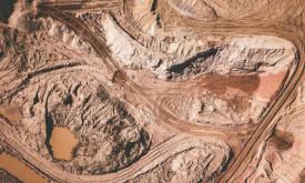
This data set provides spatially explicit estimates of the area directly used for surface mining on a global scale. It contains 44,929 polygon features, covering 101,583 km² of land used by the global...