Presenting the eStation, a software deployed in Africa to acquire and process Earth Observation data, and two of its applications for fishing (in Tanzania) and farming (in the Sahel).
...
This dataset provides the hydrological boundaries for major river basins and sub-basins across the African continent. Developed by the FAO Land and Water Division under the AQUASTAT program, the data ...
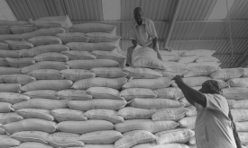
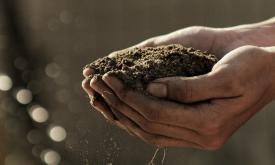
Substantial crop losses occur at various stages along the postharvest value chain. Losses result from poor handling and storage practices combined with limited awareness, infrastructure, and knowledge...
Substantial crop losses occur at various stages along the postharvest value chain. Losses result from poor handling and storage practices combined with limited awareness, infrastructure, and knowledge...
Substantial crop losses occur at various stages along the postharvest value chain. Losses result from poor handling and storage practices combined with limited awareness, infrastructure, and knowledge...
This dataset provides projections of global rainfall erosivity changes, a critical metric representing the erosive force of rainfall that drives worldwide soil and nutrient loss. These maps serve as e...
Substantial crop losses occur at various stages along the postharvest value chain. Losses result from poor handling and storage practices combined with limited awareness, infrastructure, and knowledge...
Substantial crop losses occur at various stages along the postharvest value chain. Losses result from poor handling and storage practices combined with limited awareness, infrastructure, and knowledge...