In 2020, a group of researchers carried out analysis to examine the importance of Indigenous Peoples’ lands for preserving Intact Forest Landscapes.(Fa et al.2020)They used geospatial data on th...
The Forest Landscape Integrity Index (FLII) is a composite index created to show the degree of forest integrity for 2019.
The authors identified three Forest Integrity categories:
“high ”“medium”, ...
An intact forest landscape (IFL) is a seamless mosaic of forest and naturally treeless ecosystems with no remotely detected signs of human activity and a minimum area of 500 km2. (Potapov et al.2017) ...
''Intact Forest Landscapes (IFLs) are defined as those with an unfragmented area of at least 500 km2 and which are minimally influenced by human economic activity''.(Thies et al. 2011) IFLs are critic...
Humans need increasingly more biomass for food, fodder, fiber and energy. In Africa, circa 22% of the vegetated land surface showed a decline or unstable land productivity between 1999 and 2013. Persi...
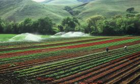
Land cover is defined as the physical material at the surface of the earth, usually documented via the interpretation of earth observations. Common land cover types include trees, grass, bare ground, ...
This indicator assesses the potential threat of rainfall- and earthquake-triggered landslides. Landslides impose significant risks to human lives and economic activities. Landslides have become more p...
This indicator measures cropland expansion, river fragmentation and pressures on marine environments through shipping and direct human impact. Land- and sea-use change is the major human influence on ...