The GHS-BUILT-V R2023A dataset depicts the distribution of built-up volumes, expressed as number of cubic meters. The data reports about the built-up volume allocated to dominant non-residential (NRES...
The GHS-BUILT-V R2023A dataset depicts the distribution of built-up volumes, expressed as number of cubic meters. The data reports about the built-up volume allocated to dominant non-residential (NRES...
Malaria, a life-threatening disease transmitted by mosquitoes, affects millions of people worldwide. Treatment and prevention efforts such as insecticide-treated mosquito nets and rapid diagnostic tes...
This dataset provides the global geographic distribution of key livestock species—cattle, sheep, and goats—for the year 2010, sourced from the Gridded Livestock of the World (GLW 3) database. Expresse...
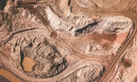
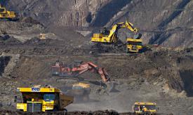
Mining has major economic, environmental and societal consequences, yet knowledge and understanding of its global footprint are still limited. These polygons represent the global mining land use detec...
This data set provides spatially explicit estimates of the area directly used for surface mining on a global scale. It contains 44,929 polygon features, covering 101,583 km² of land used by the global...
The NASA Making Earth System Data Records for Use in Research Environments (MEaSUREs) Shuttle Radar Topography Mission (SRTM) global 1 arc second (~30 metre) DEM is archived and distributed by the Lan...
The layers present the application of the Degree of Urbanisation stage I methodology recommended by UN Statistical Commission to the global population grid generated by the JRC in the epochs 1975-2030...
GHS-BUILT-S R2023A - GHS built-up surface grid, derived from Sentinel2 composite and Landsat, multitemporal (1975-2030). The spatial raster dataset depicts the distribution of built-up surfaces, expre...
Priority areas are identified using local coefficients estimated through Geographically Weighted Regression (GWR), which measures the spatially varying relationship between access to sanitation and fo...
Priority areas are identified using local coefficients estimated through Geographically Weighted Regression (GWR), which measures the spatially varying relationship between access to electricity and f...
Priority areas are identified using local coefficients estimated through Geographically Weighted Regression (GWR), which measures the spatially varying relationship between access to piped water and f...
This dataset represents a geographic clip to Africa of the
World Database on Protected Areas (WDPA),
which is the authoritative and most complete global dataset on terrestrial and ...
This spatial dataset contains the geographic boundaries and ecological evaluations of 45 Key Landscapes for Conservation and Development (KLCDs) across Sub-Saharan Africa. Building on the K...