The Regional Economic Communities (RECs) are regional groupings of African states. The 1980 Lagos Plan of Action for the Development of Africa and the 1991 Abuja Treaty proposed the creation of RECs a...
Malaria, a life-threatening disease transmitted by mosquitoes, affects millions of people worldwide. This layer highlights malaria rates among children age 2 to 10 in Sub-Saharan Africa in 2015.
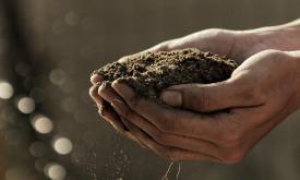
Substantial crop losses occur at various stages along the postharvest value chain. Losses result from poor handling and storage practices combined with limited awareness, infrastructure, and knowledge...
Substantial crop losses occur at various stages along the postharvest value chain. Losses result from poor handling and storage practices combined with limited awareness, infrastructure, and knowledge...
Substantial crop losses occur at various stages along the postharvest value chain. Losses result from poor handling and storage practices combined with limited awareness, infrastructure, and knowledge...
This dataset shows the global distribution of coral reefs in tropical and
subtropical regions. It is the most comprehensive global dataset of
warm-water coral reefs to date, acting as a foundation b...
This dataset provides the hydrological boundaries for major river basins and sub-basins across the African continent. Developed by the FAO Land and Water Division under the AQUASTAT program, the data ...
This dataset provides projections of global rainfall erosivity changes, a critical metric representing the erosive force of rainfall that drives worldwide soil and nutrient loss. These maps serve as e...
Substantial crop losses occur at various stages along the postharvest value chain. Losses result from poor handling and storage practices combined with limited awareness, infrastructure, and knowledge...
Priority areas are identified using local coefficients estimated through Geographically Weighted Regression (GWR), which measures the spatially varying relationship between access to sanitation and fo...
Priority areas are identified using local coefficients estimated through Geographically Weighted Regression (GWR), which measures the spatially varying relationship between access to electricity and f...
Priority areas are identified using local coefficients estimated through Geographically Weighted Regression (GWR), which measures the spatially varying relationship between access to piped water and f...
This dataset represents a geographic clip to Africa of the
World Database on Protected Areas (WDPA),
which is the authoritative and most complete global dataset on terrestrial and ...
This spatial dataset contains the geographic boundaries and ecological evaluations of 45 Key Landscapes for Conservation and Development (KLCDs) across Sub-Saharan Africa. Building on the K...