The CO2 fixed by photosynthesis is one of the most important components of the carbon cycle. Forests play a key role in this process. They represent large and persistent carbon sinks. Tree carbon stoc...
Roots are a long term and stable carbon sink, accounting for about 0.4 of the above ground biomass across biogeographical regions. Well established and developed root systems provide various ecosystem...
Park managers in many countries across Africa need to monitor and understand their parks features and overall health. They can rely on the highly detailed land cover information offered by the Coperni...
Copernicus is the European flagship programme for monitoring the Earth. Data is collected by Earth observation satellites and sensors on the earth’s surface. The Copernicus Land Monitoring Service pro...
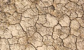
Droughts affect millions of people in the world each year and have long-lasting socioeconomic impacts. They can occur over most parts of the world, even in wet and humid regions, and can profoundly im...
Droughts affect millions of people in the world each year and have long-lasting socioeconomic impacts. They can occur over most parts of the world, even in wet and humid regions, and can profoundly im...
Increasing water scarcity and water quality issues are serious constraints, especially for Northern Africa. A comprehensive assessment of spatial and temporal precipitation frequency is the initial st...
Where are the best places to spot the most requested wildlife-watching species? This grid layer presents a richness index of top wildlife watching species/groups, including rhinos, elephants, lions, l...
The working poor are employed people who live in households that fall below an accepted poverty line. While poverty in the developed world is often associated with unemployment, the extreme poverty th...
Net official development assistance (ODA) is government aid designed to promote the economic development and welfare of developing countries. Aid may be provided bilaterally, from donor to recipient, ...
Priority areas are identified using local coefficients estimated through Geographically Weighted Regression (GWR), which measures the spatially varying relationship between access to sanitation and fo...
Priority areas are identified using local coefficients estimated through Geographically Weighted Regression (GWR), which measures the spatially varying relationship between access to electricity and f...
Priority areas are identified using local coefficients estimated through Geographically Weighted Regression (GWR), which measures the spatially varying relationship between access to piped water and f...
This dataset represents a geographic clip to Africa of the
World Database on Protected Areas (WDPA),
which is the authoritative and most complete global dataset on terrestrial and ...
This spatial dataset contains the geographic boundaries and ecological evaluations of 45 Key Landscapes for Conservation and Development (KLCDs) across Sub-Saharan Africa. Building on the K...