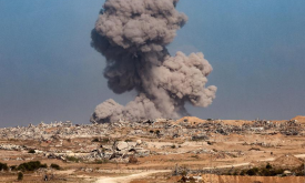
The Armed Conflict Location & Event Data Project (ACLED) dataset is a disaggregated conflict event dataset designed for real-time monitoring and analysis. It records the specific dates, locations, act...
This dataset provides estimates of the total number of under-5 children per grid cell, for Uganda. The data come from the WorldPop R2025A, version v1 release. The dataset is available in GeoTIFF forma...
Constrained estimates of the total number of people per spatial unit, derived from high-resolution population distribution data produced by the WorldPop Global Demographic Data project. These estimate...
The Global Gridded Relative Deprivation Index (GRDI) characterizes the relative levels of multidimensional deprivation and poverty, where a value of 100 represents the highest level of deprivation and...
This layer shows the percentage of stunting among children under 5 years of age, a form of chronic undernutrition reflected in low height-for-age. Stunting can result from prolonged food insecurity, p...
All known formal and informal settlements of forcibly displaced and stateless people in Africa from UNHCR’s GIS database as of November 2025. Population in the settlement. It may include several cate...
This layer represents the predicted likelihood that a given settlement is electrified, with values ranging from 0 (no electricity) to 1 (fully electrified). The data are derived from the High Resoluti...
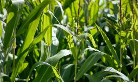
The Shannon index gives an understanding of crop diversity. It takes into account both the number of different crop types and their relative abundance.
Reference evapotranspiration (Global - Monthly - ~10 km) August 2025- AQUASTAT (FAO) AgERA5 derived.
Reference evapotranspiration per month with a spatial resolution of 0.1 degree. Unit: mm month-...
Priority areas are identified using local coefficients estimated through Geographically Weighted Regression (GWR), which measures the spatially varying relationship between access to sanitation and fo...
Priority areas are identified using local coefficients estimated through Geographically Weighted Regression (GWR), which measures the spatially varying relationship between access to electricity and f...
Priority areas are identified using local coefficients estimated through Geographically Weighted Regression (GWR), which measures the spatially varying relationship between access to piped water and f...
This dataset represents a geographic clip to Africa of the
World Database on Protected Areas (WDPA),
which is the authoritative and most complete global dataset on terrestrial and ...
This spatial dataset contains the geographic boundaries and ecological evaluations of 45 Key Landscapes for Conservation and Development (KLCDs) across Sub-Saharan Africa. Building on the K...