Many African countries, especially in the Sub-Saharan region highly depend on hydropower which is one of the energy sources that are most affected by droughts. At the same time hydropower has a huge i...
Higher energy demands in Africa has led to a wide expansion of the number of hydropower sites, mainly between the 1960s and 1980s. The construction of dams causes impoundments of rivers and reservoirs...
The hydropower installed capacity indicates the amount of energy a hydropower plant can produce in its turbines. In 2016, hydropower accounted for 54% of the installed capacity in Eastern Africa, 58% ...
This dataset shows the African power plants and their installed capacity in MegaWatt (MW). It includes thermal plants (coal, gas, oil, nuclear, biomass, waste, geothermal) and renewables (hydro, wind,...
This dataset shows the African power plants by energy generation type. It includes thermal plants (coal, gas, oil, nuclear, biomass, waste, geothermal) and renewables (hydro, wind, solar). Each power ...
Tropical moist forests have a huge environmental value. They play an important role in biodiversity conservation, terrestrial carbon cycle, hydrological regimes, indigenous population subsistence and ...
Tropical moist forests have a huge environmental value. They play an important role in biodiversity conservation, terrestrial carbon cycle, hydrological regimes, indigenous population subsistence and ...
Côte d'Ivoire and Ghana are the main largest producers of cocoa in the world. However, the cultivation of this crop has led to the loss of vast tracts of forest areas in both countries. Efficient and ...
Oil seed crops, especially oil palm, are among the most rapidly expanding agricultural land uses, and their expansion is known to cause significant environmental damage. Accordingly, these crops often...
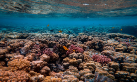
Healthy coral reefs provide a home for millions of aquatic species. They protect coastal homes from storms and support commercial and subsistence fisheries as well as jobs and businesses through touri...
Priority areas are identified using local coefficients estimated through Geographically Weighted Regression (GWR), which measures the spatially varying relationship between access to sanitation and fo...
Priority areas are identified using local coefficients estimated through Geographically Weighted Regression (GWR), which measures the spatially varying relationship between access to electricity and f...
Priority areas are identified using local coefficients estimated through Geographically Weighted Regression (GWR), which measures the spatially varying relationship between access to piped water and f...
This dataset represents a geographic clip to Africa of the
World Database on Protected Areas (WDPA),
which is the authoritative and most complete global dataset on terrestrial and ...
This spatial dataset contains the geographic boundaries and ecological evaluations of 45 Key Landscapes for Conservation and Development (KLCDs) across Sub-Saharan Africa. Building on the K...